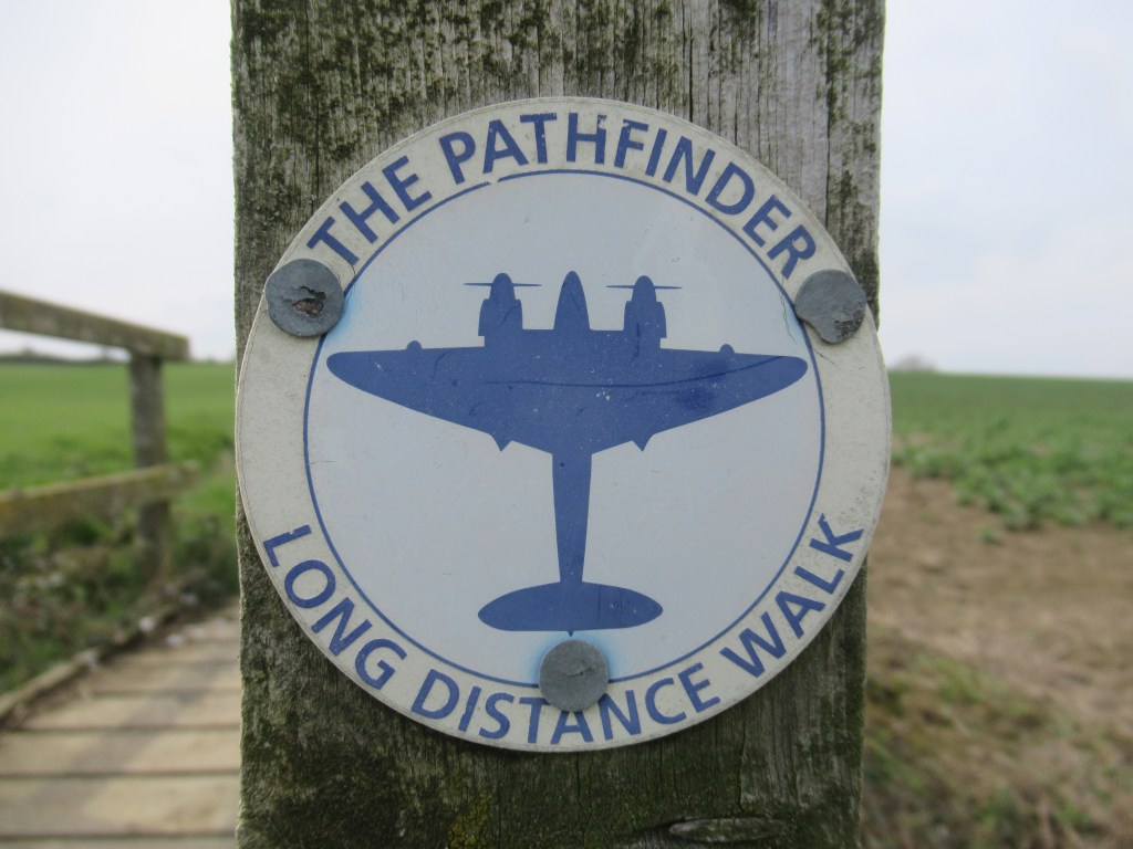
The Pathfinder Long Distance Walk is a 46 mile (74km) circular hiking trail in Cambridgeshire. Sandwiched between Cambridge and Huntingdon, it passes through mostly arable land, crosses the River Great Ouse twice, and visits many attractive villages, often with amusing names like Pidley and Yelling. The walk was designed to celebrate the Royal Air Force’s Pathfinder Force (8 Group) and it passes through the sites of some of their former airfields at Wyton, Graveley, Oakington and Warboys.
The Pathfinder Force existed between 1941 and 1945 and were tasked with locating targets on mainland Europe and marking them with flares to guide the main bomber force. During the short lifespan of the group, at least 3727 members were killed in action.

Every year in June, around 250-300 walkers and runners take part in a charity event called the Pathfinder March which involves completing the entire route in less than 20 hours, starting from 4am and ending at midnight. This is probably too much of a challenge for me, but having only become aware of this trail three days ago, I thought it would make a good weekend hike spread over three days, and with it being right on my doorstep I can sleep in my own bed at the end of each day.
DAY ONE – 21st April 2023
Dry Drayton to Swavesey
Beginning after work on the Friday, I catch a bus to the village of Dry Drayton on the outskirts of Cambridge and start immediately in the sunshine. As this is a circular walk I can start where I like, but this is the most convenient point, both for getting here and for getting home tonight. The first hour of the walk isn’t too promising as I walk on verges and occasional paths beside a busy road and over the A14 dual carriageway. Reaching the Village of Oakington, I make the first of many pub stops over the next three days. All the villages I pass through have really nice country pubs, so it would be a shame not to visit a few.

On the other side of Oakington I pass through the first of the old Pathfinder airfields. This land is gradually being converted into the new town of Northstowe, and some shiny new road infrastructure is already here in preparation for the next phases of house building. A Barn Owl is hunting over some rough grassland and glowing beautifully in the golden early evening sunlight.
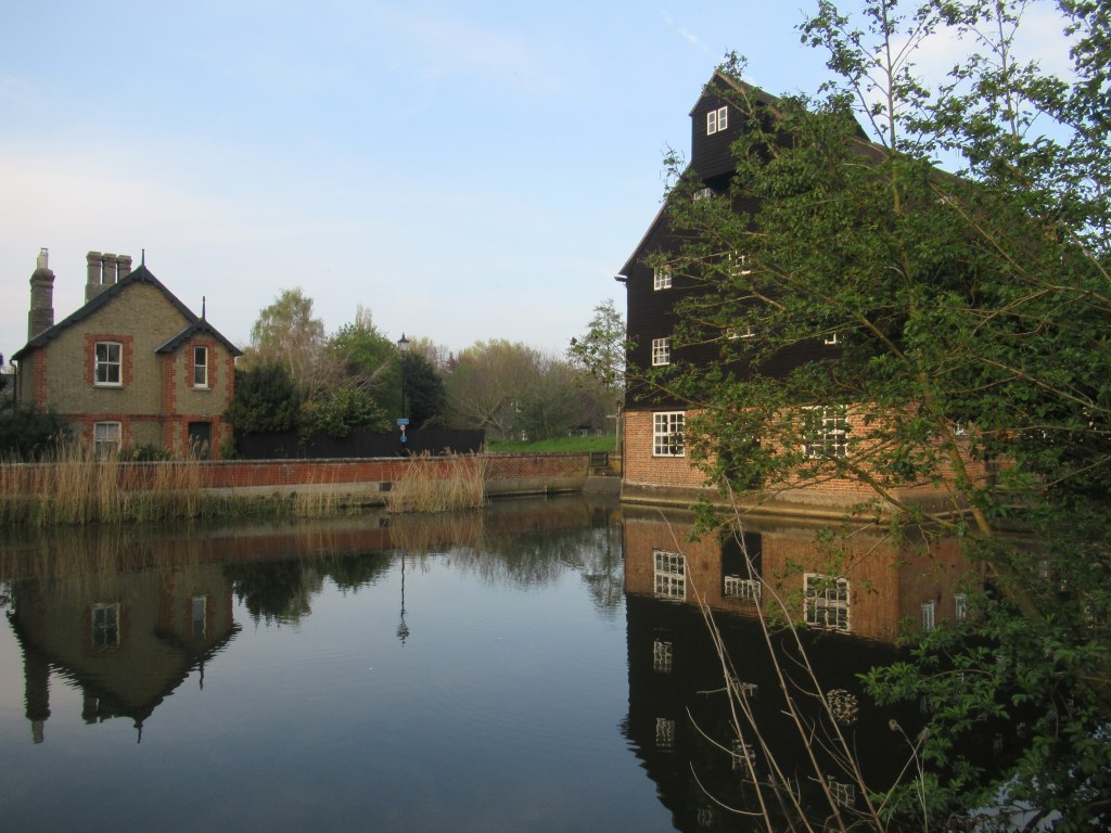
Skirting past the village of Longstanton, I have another short stretch of road walking before turning off and crossing a large grass pasture. There is no path through here but I can just about see a gate to aim for on the other side. From here there is a pleasant grassy lane all the way to the end of the day’s walk at Swavesey, where I arrive just as dusk is setting in. Despite being nearly 40 miles (64 km) from the nearest coast, Swavesey used to have a dock and was accessible by ship from the North Sea via The Wash and the River Great Ouse. Produce from the farmland of The Fens was exported from here, but all that remains of the watercourse now is the land-locked village pond and a very short stretch of cobbled dockside.
Getting home from Swavesey is easy using the Guided Busway. Opened in 2011, this is the world’s longest guided busway and it follows the line of a former railway that was closed to passengers in 1970. I use it often, as it stops very close to my home in central Cambridge and gets me out to some marvellous countryside in half an hour or so.
7.7 miles 12.4 km 3 hours
DAY TWO – 22nd April 2023
Swavesey to Godmanchester
Saturday starts off with a light mist but soon turns into another warm, sunny day. I return to Swavesey on the bus and set off, crossing the busway and heading north. This is the only part of the route with which I’m familiar. I come here often to watch birds on the complex of reserves that the RSPB is building from pits left over by aggregate extraction. It’s a part of the county I love.
The path first passes next to RSPB Fen Drayton reserve to the west. Bird migration is in full swing now and the warm spring air is filled with song. I hear my first Lesser Whitethroats of the year, joining the Chiffchaffs, Willow Warblers, Blackcaps and Sedge Warblers that have already been here for a couple of weeks. Many more birds will be arriving well into May.
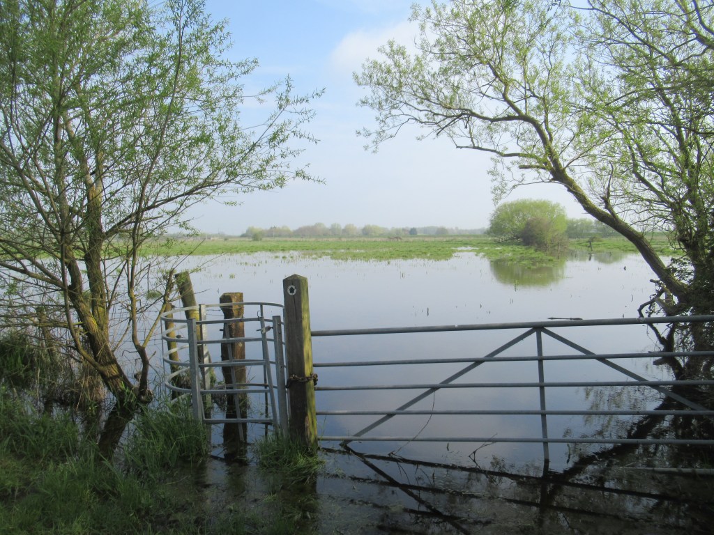
Half an hour in and I find the path ahead completely flooded and impassable. I need to get onto the raised embankment of the Great Ouse about 400m ahead, meaning I have to backtrack almost all the way back to the busway to find an alternative route. Once onto the embankment, I follow the river until I re-join the trail and then continue to Brownshill Staunch, where I cross the river. I occasionally see Harbour Seals in the water here, which must have swam up from The Wash. A strange sight in this inland county.
This area contains more RSPB reserves, most notably RSPB Ouse Fen, where sand and gravel extraction works are being converted into what will become Britain’s largest reedbed. I walk between the reserves of Barleycraft Pit on one side and Berry Fen on the other, to the village of Bluntisham. I am now back again in unfamiliar territory for the rest of the walk, as I skirt along the edge of Colne village, across the line of a dismantled railway, and into Somersham – a very attractive village with a large boulder marking where the Greenwich Prime Meridian passes nearby.
From Somersham, I continue north-west on an easy grass path through the arable land of Pidley Fen and straight through the middle of a golf course towards the village of Warboys. Leading into the village is that rarest of things in Cambridgeshire: a hill. Not much of a hill, of course, and nothing that would worry anyone from outside the county (unless you’re from Lincolnshire maybe). At the top of the hill is a bench that would make a good lunch stop, with views stretching out for miles and the big sky for which The Fens are famous.
Warboys is the most northerly point on the route and the first village where I see any mention of the Pathfinder Force – I pop into the church to see a stained glass window dedicated to them. The name Warboys has nothing to do with the military. The original Saxon name meant ‘Warden of the Woods’, which was changed to the French ‘Wardenbois’ by the Normans, and then became Warboys.

The path starts heading south-west from here across the old airfield, now mostly planted with crops. These crops are only a few inches high now, giving the impression of a vast, rolling grass prairie. Some old brick and concrete buildings look like they are left over from the war and are now being used to store farm machinery. With so much of this wide open landscape, as well as its proximity to the continent, it’s easy to see why East Anglia was the chosen location for so many airfields during WWII.
Appropriately enough, some hobbyists are flying beautifully realistic remote control planes from a scaled down airstrip of their own, complete with small hangars and windsocks. It’s only when I see these models on the ground next to the men that I realise how big they are – way larger than the Airfix planes I made as a kid.

Beyond the airfield, I reach the tiny village of Broughton, where a lockup built around 1840 still stands on the green. The last time it housed an inmate was between the wars, when a stranger on horseback arrived at the village fair and started smashing everything up for reasons known only to himself – absolute madlad!
Broughton is a perfect picture postcard village of thatched cottages, a church spire, and a pub with a gargantuan beer garden – the tables are spaced far enough apart that you and your mates can be as offensive as you like without upsetting the people at the next table. I love it here, but I know I could never afford to live in a village like this – something for which the locals can be mightily relieved.
The trail beyond the village feels like a ’proper’ long distance walk – undulating cow pastures separated by hedgerows and fences, with the only styles of the entire route, and small spinneys with Green Woodpeckers yaffling, and Buzzards circling on the late afternoon thermals. The cows and calves here are the first livestock I’ve seen this weekend.
The easily navigable path follows a stream until it arrives at the next village of Abbot’s Ripton – another beauty, but so blink-and-you-miss-it tiny that I walk right through it in a couple of minutes. Not even a pub here to slow me down.
On the B1090 I endure about 2 miles (3 km) of road walking along a busy and fast road. There is a grass verge, but it’s somewhat overgrown and lumpy. Both sides of the road have enough room to build a foot/cycle path, which would greatly improve the situation.
I pass a facility that breeds beagles for medical research, with a protest camp strung out along the road outside. A protester is suspicious of me taking photos and starts asking me questions. When he realises I’m just a hiker he offers me a brew, which I turn down as I need to get moving.
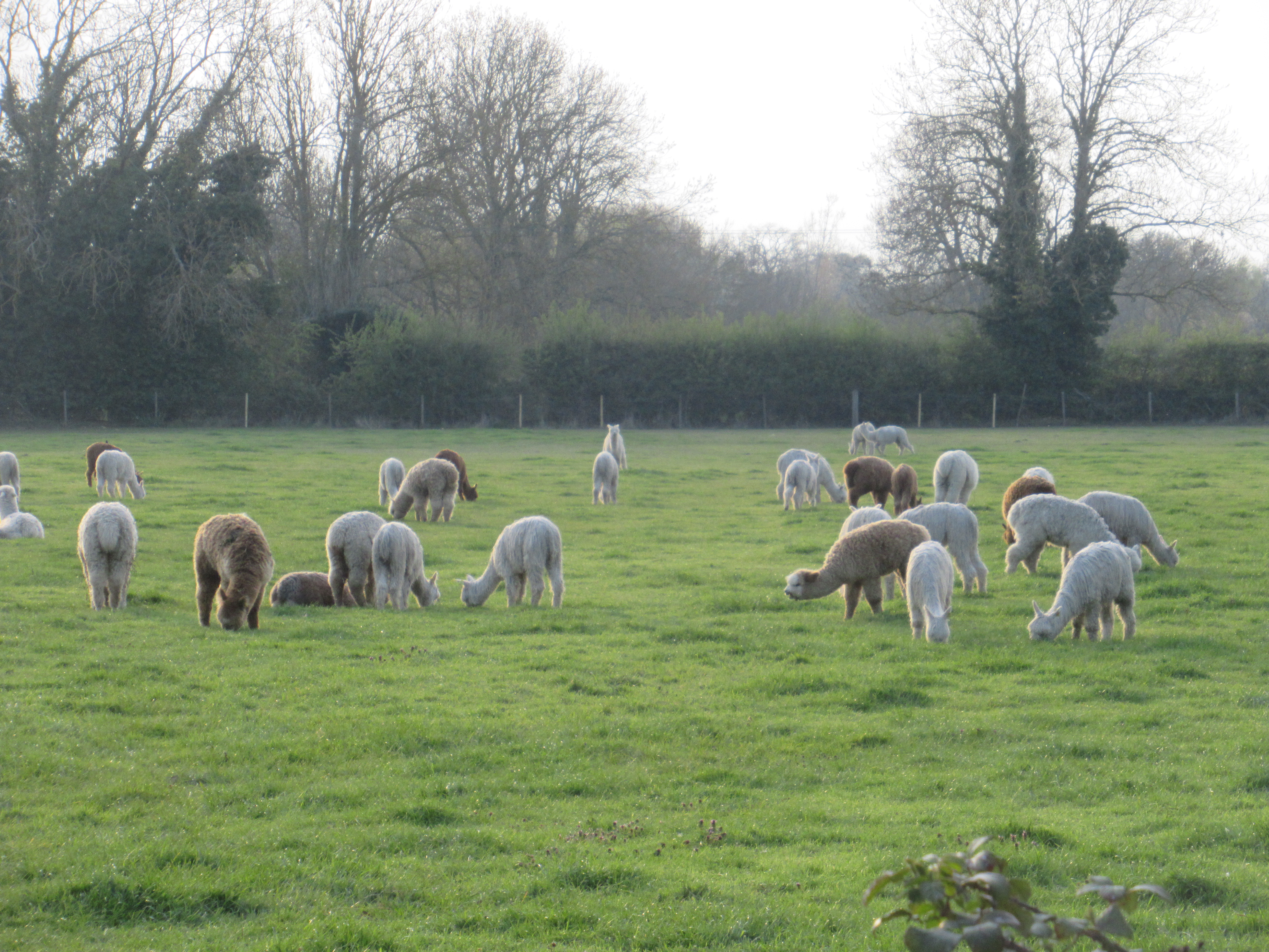
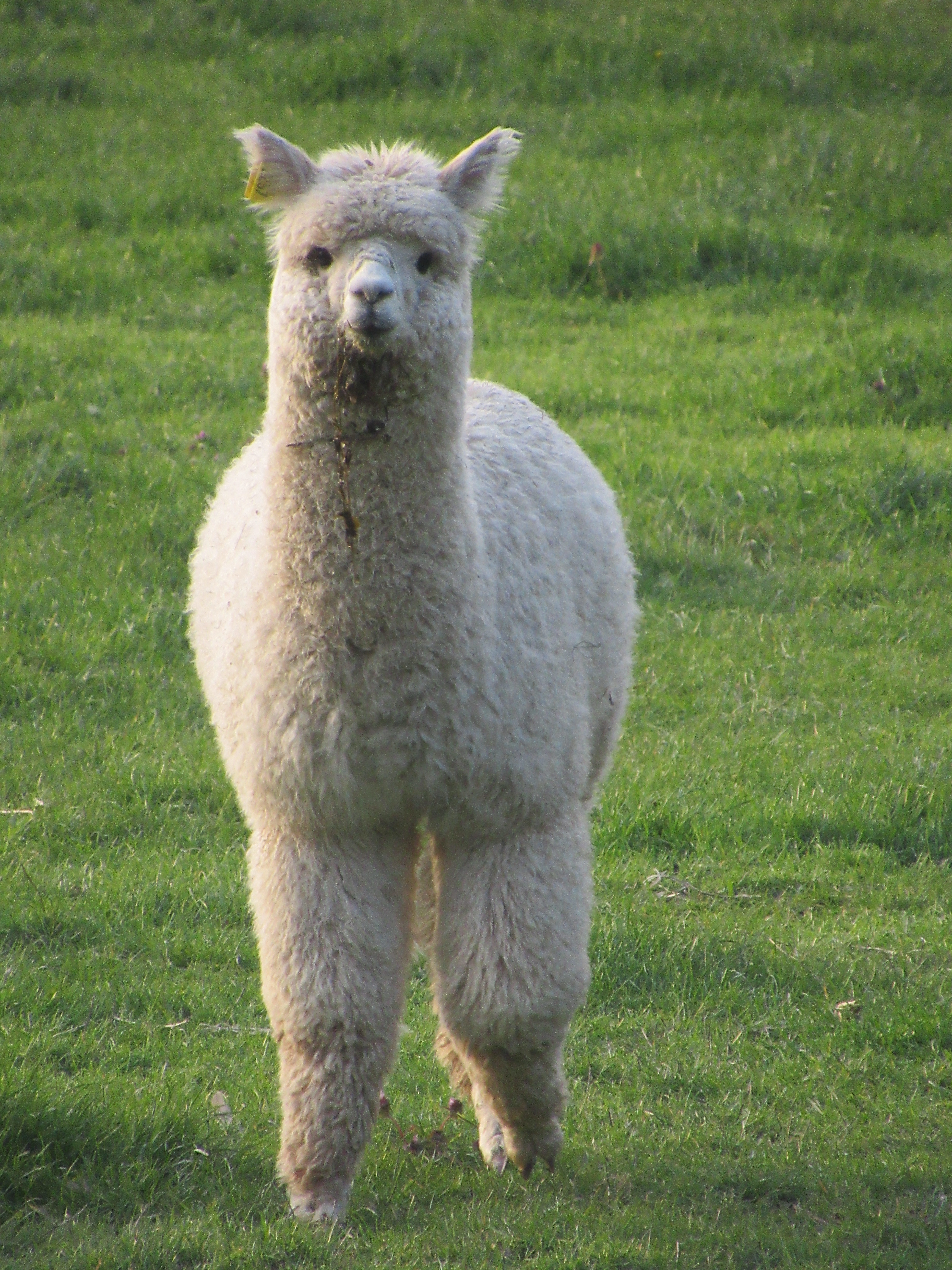
At RAF Wyton there is at least a footpath to walk on. This is the official start and finish of the Pathfinder March and still a functioning RAF property. A bus to Cambridge stops right in front of me to test my resolve. As nice as it would be to be at home with my feet up within half an hour, I press on. Turning off the main road onto Mere Way towards Houghton, I find the only other livestock on the trail aside from cows and beagles – a field full of alpacas.
Houghton is a another lovely village, with lots of fine old houses, leading down to the National Trust property of Houghton Mill, where I cross back over the Great Ouse. Across a floodplain then over another bridge to Hemingford Abbots, with some large houses that, while obviously expensive, lack the character of the older buildings seen along the way.
The rest of the day’s effort is an easy stroll through parkland and along a lane to Godmanchester, near Huntingdon, from where I catch the bus back to Cambridge.
21.8 miles 35.1 km 11.5 hours
DAY THREE – 23rd April 2023
Godmanchester to Dry Drayton
I expected it would be hard for me to motivate myself this morning. After a long day yesterday and a forecast of rain today, I thought it might be too tempting to stay in bed. As it happened, I woke up feeling refreshed and raring to go. The weather started off cool and cloudy, but the sun soon came out and it warmed up nicely. A few dark clouds came over but the rain held off.
At 7.25am, the first bus back to Godmanchester leaves surprisingly early for a Sunday service, long before anything else is stirring at Cambridge’s Drummer Street bus station.
The trail heads due south out of Godmanchester for about 3.7 miles (6 km) along a quiet country road. No traffic, but a few dog walkers. A bridge takes me over the A14 dual carriageway, which is so new here it doesn’t even appear on my OS map. Beyond here the road becomes a farm dirt track over slightly higher ground through open arable fields. Good numbers of Skylarks and Corn Buntings are singing on their breeding territories, as well as the odd Meadow Pipit and Yellowhammer. A Common Whitethroat is another new bird for the year, to go with yesterday’s Lesser Whitethroat.
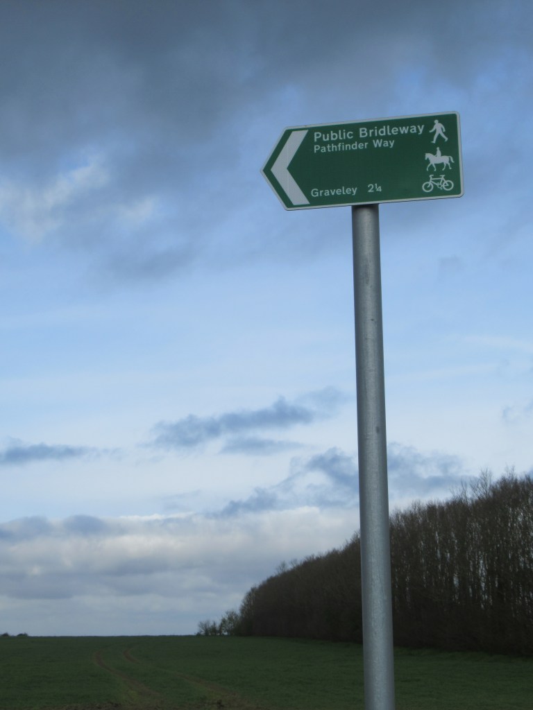
The track comes out onto a road which descends into the village of Graveley. This is the fourth and final Pathfinder airfield site, and the village sign features bombers and an airman. At the other end of the village, the path undulates through a pleasant wooded lane filled with bluebells. This is one of the most pleasant stretches of the whole walk, and definitely the hilliest – we’re clearly not in The Fens any more.
In less than a mile I arrive in the village of Yelling which, despite the name, is actually very quiet. The hills continue for over a mile (2 km) of slightly sketchy road walking before leaving the tarmac and descending into a small valley, crossing a stream, then ascending out again to arrive in the village of Papworth Everard. If all those hills have finally taken a toll on your heart, have no fear: Papworth Hospital is only a short crawl from here! (I should probably point out that Papworth’s famous cardiac hospital was moved to Cambridge some years ago, so Papworth Everard is no longer a convenient place to have a heart attack).
This is the busiest place I’ve passed through, and feels like a proper town. There are shops here, and a few places to eat. The route leaves Papworth via a small wood – the only real woodland on the whole trail. Lots more bluebells here, and some newly planted trees giving a much-needed expansion to Cambridgeshire’s woodland cover.
I once again cross open arable land to reach Elsworth. As it’s past beer o’clock, I make the only pub stop of the day. On leaving the village, I’m surprised to find myself walking through the RSPB’s Hope Farm. I knew it was in Cambridgeshire but wasn’t sure exactly where. This is a bit dim-witted of me because, as an RSPB volunteer, I was once given a guided tour of the property. It isn’t a nature reserve, but a working farm purchased by the RSPB in 2000 to develop and demonstrate wildlife-friendly farming techniques, with the goal of improving biodiversity without reducing crop yields.
The rest of the days walk is a straightforward march through farmland, with more trees and hedgerows than most other parts of the route, until I arrive back in Dry Drayton. I pick up the pace for the last couple of miles to see how close I can get to the 20 hour time limit of the Pathfinder March. Totting up my timings, I find that I walked the route in 20 hours and 25 minutes, without really hurrying. Of course, I didn’t do it all in one go, so I’m still not sure one way or the other whether I could handle the full march.
16.4 miles 26.4 km 6 hours
This was an easy and pleasant walk on mostly flat paths with only a few low hills. Navigation was straightforward, with waymarks featuring a blue Mosquito aircraft – the nose of the plane indicating the direction of the path. However, don’t expect to be able to follow the route using only these waymarks. They were absent from some sections, often completely faded in the sun, and sometimes consisted of ragged laminated sheets cable-tied to a gate. Fortunately the route is marked on OS maps and is covered by OS Landranger 142, 153 and 154.
Refreshments are easy to find. You’re never far from the next village and they nearly all have a pub, and often a convenience store too. Everyone I met was very friendly and there are good bus connections to Cambridge and Huntingdon in many places. The only negatives were the three fairly short sections on busy roads – especially annoying in areas where a path could easily be created. This minor gripe aside, I thoroughly enjoyed the walk and was reminded that even right on my doorstep there are still new places to discover.

Leave a comment